
Because of the ongoing and historic drought in parts of the West, there are some stretches of the ride where potable water might be scarce. Worst scenario is that it may be necessary to carry up to a gallon of water for some stretches: water is heavy and a gallon weighs 8.4 lbs. Water filtering will also be necessary to avoid illnesses caused by bacteria.
Food will be what we can find in small towns and an occasional carb/protein binge at a local diner or brewery. As you can imagine, nutrition is vital to staying healthy and calories are incredibly important. We expect to be burning 600-700 calories per hour for anywhere from 4-7 hours per day. Some blogs suggest an intake of 6-8,000 calories per day just to maintain one’s weight! On my 1985 ride, finishing off a pound of fig newtons was a typical appetizer while dinner was cooking. Food tastes really good on a bike ride. It is also heavy and we may have to forego the bunches of bananas in the produce aisle...but that won’t prevent us eating a watermelon in the parking lot as a snack. We will favor lighter products that pack nutrition: powdered peanut butter, couscous, quinoa, etc.
We have purchased some dried food that Molly will mail to us at designated towns so that we can make sure we are getting the calories we need. (Cookies always welcome!)

Freeze-dried Adventure Meals! Yum!

On my cross-country bike ride in 1985, I started out with my good friend Tim Tiernan who I went to school with at Berkeley. We connected in Lone Pine, a small town in California’s Owens Valley after I burned through the Mojave Desert (literally). We proceeded on and through Death Valley (pictured above) which is probably one of the most stunning landscapes on earth especially if you are on two wheels (and if you like the desert).
After many years of work, living on opposite coasts, and raising kids, we saw each other infrequently but always picked up where we left off. I last saw Tim in February, 2019 when we met in Las Vegas and then retraced (by car) our Death Valley route and, as two old farts often do, we impressed ourselves that we accomplished that 1985 ride. We picked up where we left off. We talked about everything including the possibility of riding the Great Divide Mountain Bike Ride together, and he had agreed to join me for at least part of the journey.

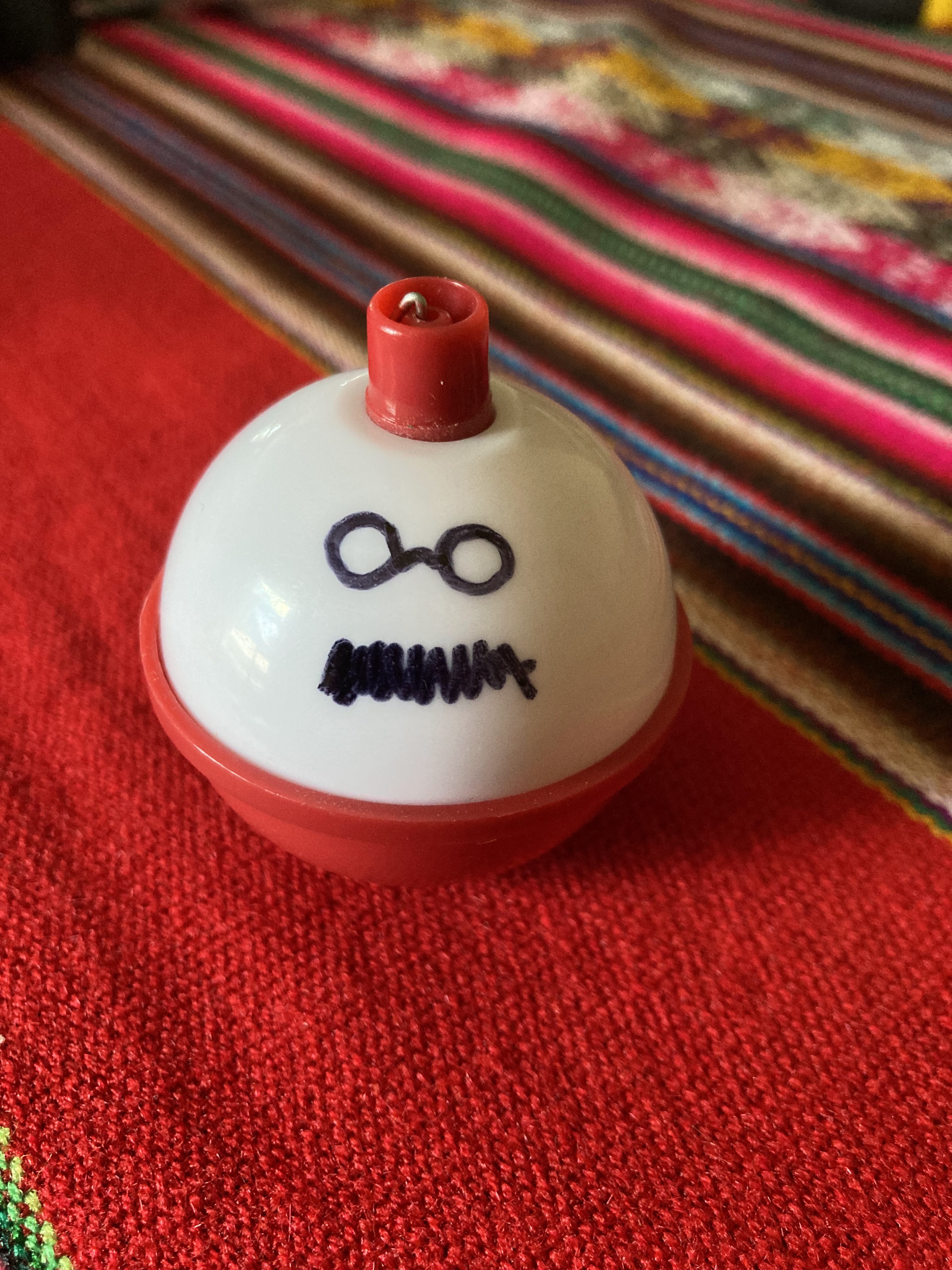
He had wavy red hair, pale skin, a terrific mustache, and earned the nickname “bobber” (as in the fishing accessory) when he was a camp counselor. So, to honor his memory, I will attach a bobber to my bike and carry his memory and friendship for the length of the trip. He was also a loving partner to Katie Quinlan and an amazing father to Bryce and Marty. I will be thinking of his family as well.
Tim’s gift of teaching connects with the mission of Apprentice Learning, the educational group I am fundraising for on this ride. The motto of AL is “Ignite Purpose” and this is also its mission.
Educators and organizations who care about the struggles that kids face work very hard to bridge the gap between opportunity and structural disadvantages. Tim did this. My current riding partner Noreen does this. Apprentice Learning is doing this.
On the eve of my departure for this next adventure, I remember Tim Tiernan, whose heart was as expansive and beautiful as the American West.
“Whose woods these are, I need to know.” –paraphrase of Robert Frost
While trying to understand the lands through which I will pass on this trip, I thought I would be able to list the indigenous tribes in order from north to south and then focus on the history and attributes of these peoples, and that the tribal boundaries would be explicit.
Instead, understanding ancestral lands is much more complicated. The idea of creating definite boundaries for certain tribes sounds like it may be an outside culture's convention, and the mapping possibly a surveyor’s trick rationalizing how others think of land development, definition, and ownership. In fact, it is believed that any territorial limits associated with one tribe or another was much more fluid, overlapping, and probably has changed over time.
Anthropologists, no matter how well meaning, may have helped impose ideas of boundaries which made dispossession that much easier. For example, because many of the territories were so large, physical boundaries (rivers, mountain ranges, valleys, etc) helped rationalize the territories' perceived boundaries. Even the indigenous makers of this interactive map reveal the following: “This map does not represent or intend to represent official or legal boundaries of any Indigenous nations. To learn about definitive boundaries, contact the nations in question.”
In the current trend to be more aware of indigenous ancestral lands, corporations and municipalities appear to be making good faith efforts to ceremonially acknowledge the ancestral land, even as it is used as a hockey rink, mall, or national park. The “acknowledgment” can unfortunately emphasize “this was your land but it’s ours now” without any gesture or intent as to what might be done to rectify past wrongs. Indigenous anthropologists have asked non-indigenous social scientists to stop defining boundaries and naming ancestral lands since the naming is limiting the understanding of how indigenous people used the land.
The map referenced here contains names of tribes, many of which I cannot even pronounce; for orientation, they provide a graphic layer which adds “settlers” towns and cities. The base map also contains land forms (mountains, valleys, lakes).

At this time, I think I am passing through the following ancestral lands of first peoples (Canada) and native American (US) indigenous people prior to their “relocation” and sequestration on reservations. I am basing this on the study of the map, so I can’t say this is 100% accurate. I will keep my eyes open as I ride.
For this blog I can only name tribes to be aware of them. I could not possibly provide more info on each and do them the justice they deserve. More than one tribe is listed below as their lands and territories overlap according to the map.
Alberta (CA)
Jasper Aseniwuche (Rocky Mountain), Secwépemc, Michif Piyii (Métis), Tsuu T’ina, Stoney, Mountain Métis.
Banff Michif Piyii (Métis), Niitsitpiis Stahkoii (Blackfoot)
Elkford ktunaxa amakis, Stoney, Tsuu T’ina
Fernie ktunaxa amakis
Roosville ktunaxa amakis
Montana (USA)
Eureka ktunaxa amakis
Whitefish ktunaxa amakis, Salish
Flathead Salish
Helena Salish, Blackfoot
Butte Salish
Wise River Salish, Shoshone-Bannock
Lima Shoshone-Bannock
Big Springs Cheyenne, Shoshone-Bannock
Wyoming
Jackson Cheyenne, Eastern Shoshone, Shoshone-Bannock
Pinedale Cheyenne, Eastern Shoshone, Shoshone-Bannock, Apsaalooké
(Crow)
Atlantic City Cheyenne, Eastern Shoshone, Apsaalooké (Crow)
Rawlins Cheyenne
Colorado
Slater Eastern Shoshone
Steamboat Cheyenne , Eastern Shoshone, Núu-agha-tuve-pu (Ute)
(these characters for the Ute appear as noted, not a typo)
Kremmling Cheyenne , Núu-agha-tuve-pu (Ute)
Breckenridge Núu-agha-tuve-pu (Ute)
Salida Cheyenne , Núu-agha-tuve-pu (Ute)
Platoro Núu-agha-tuve-pu (Ute), Pueblos, Diné Bikéyah
New Mexico
Abiquiu Núu-agha-tuve-pu (Ute), Pueblos,
Grants Pueblos, Shiwinna (Zuni)
Pie Town Pueblos, Chiricahua Apache, Shiwinna (Zuni)
Silver City Chiricahua Apache
Antelope Wells Chiricahua Apache, Janos
Columbus Chiricahua Apache, Janos, Pescado
At 64, I am training a little more seriously for this cross-country journey. I invested in a nice bike, did not make my own bags, and have cell and satellite connections in lieu of the stars and a AAA map. We do get more cautious (or is smarter?) as we get older.
Recently, I’d been hoping for a sign that now is the right time for this trip. I heard a familiar bird call while on a training ride in the Blue Hills in Canton, MA. It was the unmistakable call of an Eastern Wood-Peewee. I learned this bird’s song well on my 1985 cross-country bike trip, especially when I was riding solo from Nashville to Boston. Once I made it to the Smoky Mountains and the Blue Ridge Parkway, I heard the Peewee calling at all times of day, every day, during that earlier journey. It was a companion and a sign that everything was OK. Peewees prefer the woods to settled areas; they love the Blue Hills, just two miles south from my home (as the Peewee flies).
On every training ride though the Blue Hills or in the woods west of Boston for the past two months, I have heard the Peewee singing. Sounds crazy, but I have taken it as the sign I was looking for. I’m guessing there will be other spirit animals to meet out west. I prefer the diurnal ones. If I have a choice, (and I don’t): something other than a grizzly bear or a persistent mosquito, of which there are plenty.

Eastern Wood-Peewee Contopus virens
Here is a link to a variety of their songs:
https://www.youtube.com/watch?v=-B-GnePZWXg
Starting out in Jasper, we will be a mighty team of three. My brother Mark of Boston, MA will be joining for a week until Banff. Going for the duration is my cousin Noreen of Bar Harbor, Maine.
I mentioned the Great Divide Mountain Bike Ride to Noreen about 6-7 years ago. She emailed this past January saying the thought of the ride had recently become a subject of her dreams (I’m not the only one). I wrote back saying I had it half-planned for an August departure. She ruminated for one day and then I got her answer: “I’m in!”

We have never bicycled together which can be a wild card: respecting and working with another biker’s pace and rhythms. We’ll work it out.

Getting back to brother Mark. On a daily basis, Mark bikes more than he walks and he is fast. He is a good lead dog. Since he will be joining us on relatively skinny tires for the paved portion of the first leg of the Icefields Parkway, Mark is going to be blindingly fast compared to me and Noreen. Since most of the campgrounds along the parkway are first-come-first served, Mark will be our scout, securing a campsite and having lunch ready by the time we arrive. Well, at least get the campsite. It will be great to ride with Mark and I have a feeling he is going to have seriously mixed emotions about leaving the trail after a week.
Never to be underestimated: although Molly will remain in Boston, she is a solid source of support, initially encouraging me to do this ride (without hesitation), setting up this blog, mailing care packages to established P.O.s, being available to help map possible reroutes due to fires, etc. She did this expertly when our son Erickson hiked the Pacific Crest Trail in 2017. I know this trip would not be possible without her. Thanks Molly!
And last but not least: all of you are part of this team! Thanks to all who have donated to Apprentice Learning via the Rodman Ride for Kids, and thanks for following along!

Fortunately, I am not the first nor the 1,000th person to do this particular ride. There are excellent maps through Adventure Cycling, a terrific bike advocacy and trail building organization which has been planning and mapping trails and routes for bikes for over 50 years. Several good guides are also available about the realities of biking on dirt roads and trails, often without seeing a town for several days at a time. And—of course—there are YouTube videos with every imaginable opinion about what not to bring and what you must have. Equipment costs can run into hundreds if not thousands of dollars, so some innovation, some doing without all the bells and whistles, and some “buying used” is necessary if you’re not flush. It’s doable.
On the trip in 1985, I scrimped to put together a travel kit that was less than optimal, and it turned out to be fine. Because of the uncertainties of biking in wilder areas, this time I am adhering a little closer to the riders who have gone before.
Planning has been fun. I started last October laying out an itinerary and bought the excellent Great Divide Mountain Bike Ride (GDMBR) trail map set from Adventure Cycling. How to figure out how many miles/day would be possible, researching difficult parts of the tour with regard to water/food scarcity or climbing grades, and where grizzly bears are the most common, and where you can camp and where you cannot. The guides are good for this and if you like maps, the GDMBR maps are wonderful to pore over for hours.
Similarly, there are lots of lists about what to bring. By the time you account for tent, sleeping bag, pad, tools, water storage and filtering, eating kit, food, rainwear, satellite unit, medical kit, etc., it leaves you room for about a t-shirt and a pair of shorts. Here is a picture of what I have to carry—the only thing left is to figure out how to get the bike to go up hills.
Not sure how much this will all weigh and maybe it’s better not to know!

Top Row: H2O filter, 50’ cord, cat hole shovel, tent stakes, tent and fly, sleeping pad, bandana (2), hat, sneaks, shorts(2), shirts(3).
3rd Row: journal, maps, map holder, water bottle(3), sleeping liner, headlamp, tail light, bug net, pillow, emergency blanket, gloves, sleeping bag (black off to the side).
2nd: Row: pump, lock/cable, collapsible water bottle, benadryl, sunglasses, cook set (stove, pot/pan, utensils, towel), food (partial!), raincoat, socks (3), tights, thermal jacket.
Bottom Row: Bike tools, extra tube, vitamins, pain relievers, prescriptions, lip balm, sunscreen, first aid, toiletries, wipes, phone, satellite connection, battery, earphones, rain paints, shoe covers, down vest.
Not shown: helmet, riding boots, spare parts, spare tire, stores bags, emergency whistle, bear spray, gas canister (cooking), head light, cyclometer, reading glasses, aches and pain, elation.

My other cross-country bike experience was in a previous life when I was 27 and moving back to my native New England after 13 years on the west coast. The idea of a cross-country bike ride was something that had captivated my imagination since I was a kid.
I made the decision in December 1984, went on a couple of 50 mile training rides, sewed my own panniers (saddle bags), threw together some clothes and a tent, fixed up my 10-year old ten-speed, and set off from San Diego in March 1985. The photo above is with my mom Audrey, all loaded up on the first day of that trip (note those panniers!).
The trip was as amazing as I hoped it would be. By the Numbers: 4200 miles, 80-days, 7 flat tires; new rear rim; expenses: $748.93, or $9.36/day.
I didn’t think it would take 37 years to get back on the cross-country kick, but here we are.

I’m flying from Boston to Edmonton, Alberta, Canada on July 31, taking a day to acclimate and then hitting the road. We’ll take a week from Jasper to Banff and try to secure “first-come-first served” campsites along the way and take in some hikes.
The best-laid “plan” is to be near the Mexican border by the last week in September. The deadline for me is to be in Denver on October 1 or 2, five days before the wedding of my younger son and his fiancé. You know what they say about best-laid plans. So many contingencies: weather, drought (access to water), fires, small mechanical issues, large mammals, old knees and hips. The official story is that wherever I am on September 30, I will grab a bus or a plane and head up to Denver. No doubt flexibility and planning is crucial: fires, even distant ones, can be a health (smoke) and safety hazard and reconfiguring a route may be required, which is a little more difficult to do on a bike.
By the way, this isn’t my first rodeo. More about my prior long-distance biking experience in the next post. But here’s a photo from that earlier cross-country bike ride.
Can you guess the year?

That's me in the middle with my good friend Rick from Oakland, CA and Sven from Hamburg, Germany, who we met along the way.
Since some of you have asked: What is the actual route of the Great Divide Mountain Bike Ride?
The route is approximately 2,700 miles; the terminus points are Jasper, Alberta and Antelope Wells or Columbus, New Mexico along the Mexican border. It stays within about 40 miles of the actual Continental Divide and crosses the Divide 32 times: the lowest point is a couple thousand feet, the highest is Indiana Pass, +11,200FT above sea level. It is primarily routed on active logging and forest service dirt roads (about 80%) with the balance being a split between paved roads (10%) and single-track paths (about 10%).

This is a terrific map of the route: you can zoom in on it and see key points along the way. Along the left edge is the route profile which looks more like the heart rate of someone who is riding this. There is about 150,000 ft of cumulative elevation gain (about five Mount Everests). I prefer to think of this as 150,000 feet of downhill gliding reward. Interestingly, this route is not considered very difficult ranking 5.5/10 in terms of technical difficulties since it is mostly on dirt roads. (So let me know if you want to join us at any point along the way.) I am guessing the difficult part is getting up every morning and getting back on the saddle.
Hi Everyone—I’m about to embark on a ride from the Canadian Rockies to the border of Mexico. The route is called the Great Divide Mountain Bike Ride and it passes through two Canadian provinces and five western states and stays within about 40 miles of the Continental Divide. Pedaling for approximately 3,000 miles, I hope to accomplish the ride in 60 days, August to October. I have been dreaming about this ride for about 15 years—thought I better just go ahead and do it!
I’d like to invite any and all to accompany me on the adventure through this blog. You can bookmark this page and check in now and then via this link: https://timsgreatdivideride.blogspot.com. I probably won't be able to post every day but hope to be able to share the experience with you in words and pictures.
I’d also like to invite you to support my fundraising efforts. It’s symbolic that I’m "tackling the great divide" in support of Apprentice Learning (AL), an organization that addresses the very real divide for youth who live within sight of the Boston skyline but may never have access to employment opportunities in those work spaces without some bridge building. Find out more here.
As I prepare to start riding in August, I'll share a few posts about that preparation. For instance: what do you pack for a 3,000 mile bike ride (and not pack too much)? I'm still figuring that one out. Here's my bike half-loaded up for a training ride this past weekend in the lovely Blue Hills:
